 Facility
Maintenance Help
Facility
Maintenance Help
Introduction
Welcome to Facility Maintenance. Facility Explorer is available to the
public. Facility Maintenance has many
additional features and requires a login to see some sensitive layers. Also, for users to edit locations, they must
have rights for a particular program.
Please refer to the Facility Explorer Help on how to use basic features, such as:
- Use the Map
- Search & Zoom
- Facility List
- Facility Detail
Editing Locations
Move Location (Points)
1. Find the location to move, and zoom in to a view that shows the current location and the new place you want to move it to.
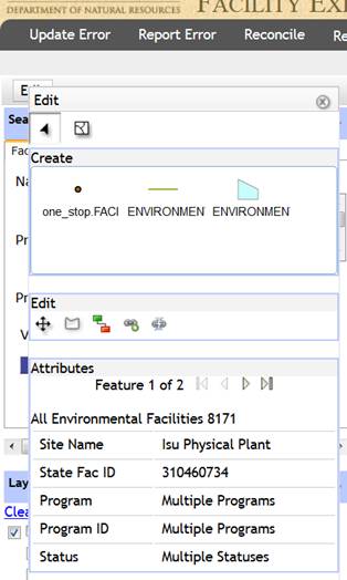
2. Click Edit (in upper left) to open the Edit window.
3. Select the location to move:
·
Click ![]() (Select
Feature).
(Select
Feature).
· Draw a box around the location that you want to move.
4. Click ![]() (Move Feature) in the Edit section of the
Edit window.
(Move Feature) in the Edit section of the
Edit window.
5. Click the point on the map for the new location.
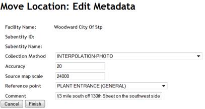
6. A “Move Location: Edit Metadata” dialog window should appear.
· Select the Collection Method, Accuracy and Reference Point values. Note: Accuracy and scale will default based upon collection method, but they can also be overwritten.
· Type in a comment if more explanation is needed.
· Click Finish.
· The map will then refresh (this may take a few seconds)
Refer to Metadata Explanation if needed.

Move Location (Lines/Polygons)
1. Find the location to move, and zoom in to a view that shows the current location.
2. Click Edit (in upper left) to open the Edit window.
3.
Click ![]() (Edit Line/Area).
(Edit Line/Area).
4. Click on the line or polygon you want to edit.
5. Vertices will now appear on the shape, which you can drag to change the shape. In addition, white “ghost” vertices will also appear. You can click on these to add new vertices.
6. When finished editing the shape, click in the middle of the line or polygon.
7. A “Move Location: Edit Metadata.” dialog window should appear.
8. Select the Collection Method, Accuracy and Reference Point values. Note: Accuracy and scale will default based upon collection method, but they can also be overwritten.
9. Type in a comment if more explanation is needed.
10. Click Finish.
11. The map will then refresh (this may take a few seconds)
Refer to Metadata Explanation if needed.
Add Facility Location
Before you add a location:
1. Basic program data should already have been entered into the program database, and a permit # or program ID has been assigned.
2. Check to see if the location is already in Facility Explorer. Use Search criteria AND check the map where it should be.
a. If the facility is already in Facility Explorer, then you would add your program to an existing location. See Add Program Interest below.
b. If not, then you would Add a location
Add a location :
1. Find on the map where the facility should be located by using “Zoom To” and/or map navigation.
2.  Click
Edit (in upper left) to open the
Edit window.
Click
Edit (in upper left) to open the
Edit window.
3. In the Create section of the Edit window, select the geometry type for the new location: point, line or polygon.
4. Move to the map and add the location by clicking (for points), or drawing a line or polygon. For lines or polygons, double click when finished.
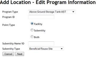
5. An “Add Location – Edit Program Information” dialog window should appear.
· Select the program type, enter Program ID, click the Facility radio button, then click Next.
· At this point, the program ID is checked to verify it exists in your program database, and that it does not yet exist in One Stop. Appropriate error messages should be returned if either of these validations failed.
6. An “Edit Metadata” dialog box should appear.
· Validate that the Facility Name listed is the one you want to add.
· Select the Collection Method, Accuracy and Reference Point values. Note: Accuracy and scale will default based upon collection method, but they can also be overwritten. Click Finish.
Refer to Metadata Explanation if needed.
7. The map will then refresh (this may take a few seconds).
Add Program Interest
Use this function if the facility already exists in One Stop for another program, but not yours.
1. Select the desired facility
· Click Edit (in upper left) to open the Edit window.
·
Click ![]() (Select
Feature).
(Select
Feature).
· Draw a box around the facility. A list of attributes should appear at the bottom of the Edit window. Verify the facility is the one you want to attach your program interest to.
2.
 Click
Click
![]() (Add Program Interest) in the Edit section
of the Edit window
(Add Program Interest) in the Edit section
of the Edit window
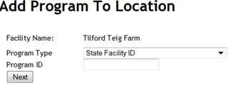
3. An “Add Program to Location” dialog window should appear.
· Select the Program type from the drop down menu, enter the Program ID and click Finish.
Add Subentity Location
1. Basic program data for the subentity should already have been entered into the program database, and a subentity name or ID assigned. (Does not apply to Solid Waste)
2. Find on the map where the subentity should be located by using “Zoom To” and/or map navigation, or by searching for the facility the subentity will be attached to.
3. Click Edit (in upper left) to open the Edit window.
4. In the Create section of the Edit window, select the geometry type for the new location: point, line or polygon..
5. Move to the map and add the location for the subentity by clicking (for points), or drawing a line or polygon.
6. An “Add Location – Edit Program Information” dialog window should appear.
· Select the Program Type and enter the Program ID for the facility the subentity will be attached to.
· Select the “Subentity” Point type. (If the facility does not yet exist and the facility and subentity are at the same location coordinates, then “Both” can be selected, and both the facility and subentity will be created. The “Both” option does not currently work for UST, but this will be added soon.)
· Enter the Subentity name or ID, select the Subentity Type from the drop down, and click Next.
7. An “Edit Metadata” dialog box should appear.
· Select the Collection Method, Accuracy and Reference Point values. Note: Accuracy and scale will default based upon collection method, but they can also be overwritten. Click Finish.
Refer to Metadata Explanation if needed.
8. The map will then refresh (this may take a few seconds).
 Link Facilities
1. Click Edit (in upper left) to open the Edit window.
2. Select the two locations to link:
·
Click ![]() (Select
Feature).
(Select
Feature).
· Click and drag to draw a box around the two locations.
3. Click
![]() (Link) in the Edit section of the Edit
window.
(Link) in the Edit section of the Edit
window.
4. If you have selected more than two facilities, you will be given the option to click on the two facilities from a list.
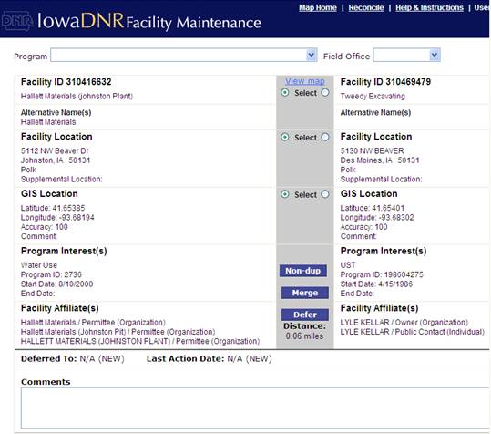
5. If you have selected only two facilities, the screen at right will display showing the two sites side by side (in the Reconciliation module).
·
For each of the three radial button pairs in the
middle column, click on the side for which site’s data will be displayed in
Facility Explorer:
--Top: Facility Name
--Middle: Facility Address
--Bottom: Latitude/longitude coordinates
(Note: the Latitude/longitude will be
written back to program databases, but not the facility name or address.)
· Click on the Merge button (bottom of center column) to link the sites.
· Click on Map Home (at the top) to return to the main Facility Maintenance page.
Unlink Facilities
1. Click Edit (in upper left) to open the Edit window.
2. Select the location to unlink:
·
 Click
Click
![]() (Select
Feature).
(Select
Feature).
· Draw a box around the location. Verify the facility is the one you want to move.
3. Click
![]() (Unlink)
in the Edit section of the Edit window.
(Unlink)
in the Edit section of the Edit window.
4. If you have selected more than two facilities, you will be given the option to select the facility from a list.
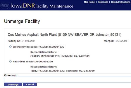
5. If you have selected only one facility, the screen at right will display (in the Reconciliation module).
· Click on the radial button for the site to remove from this state facility ID.
· In the Comment section (at the bottom), type in an explanation for why it is being unlinked or the source of the information to help others understand the level of confidence in unlinking. (For example, “Address was wrong for the Emergency Response site according to the operator.”)
· Click on the Unmerge button to unlink the site.
· Click on Map Home (at the top) to return to the main Facility Maintenance page.
Program IDs & Tips
Program IDs & Subentity IDs
The table below contains the sample format for the identification numbers to use for different programs.
|
Program |
Program ID |
Subentity ID |
|
Air |
Plant
number, such as |
|
|
Animal Feeding Operations |
AFO Facility ID, such as |
|
|
Contaminated
Sites |
Site
ID, such as 330 |
|
|
Solid
Waste |
Permit
number, such as |
Solid
Waste Land Application &Beneficial Reuse:
area name |
|
Tier 2 Chemical Storage |
Tier II ID, such as |
|
|
UST |
Registration
number, such as 198601234 |
LUST
#, such as 9LTZ99 |
|
Wastewater
NPDES Permit |
NPDES
state number, such as 6342001 |
·
NPDES facility design #, such as”1” ·
NPDES outfall #, such as “001” |
|
Wastewater
NPDES Industrial Contributor |
NPDES
#, followed by “IC”#, such as 6342001IC2 |
|
|
Water
Supply Operating Permit |
PWS
ID, such as IA0140007 |
·
SDWIS well #, such as WL01 ·
SDWIS Treatment Plant #, such as TP01 ·
SDWIS Intake #, such as IN01 ·
SDWIS infiltration gallery #, such as IG01 |
|
Water
Use Permit |
Permit
number, such as 2556. |
·
Water Use well #, such as 101 ·
Water Use stream#, such as 201 ·
Water Use reservoir #, such as 301 |
|
Field Office |
FOCD number, such as 3082 |
|
|
Spill Incidents and |
Spill number, such as 080907-AHB-1031 |
|
NPDS Guidance
|
Type |
|
Description |
Reference Point |
|
Treatment
Type |
|
|
ACTIVATED SLUDGE |
011 Liquid Waste Treatment Unit |
|
AERATED LAGOON |
010 Lagoon or Settling Pond |
|
LAND APPLICATION |
011 |
|
NO TREATMENT |
017 Process Unit |
|
OTHER (usually septic tank, sand filter or
catch basin) |
011 |
|
OXIDATION DITCH |
011 |
|
PRIMARY TREATMENT |
011 |
|
ROTAT BIOL CONTACTOR |
011 |
|
SEQ BATCH REACTOR |
011 |
|
TRICKLING FILTER |
011 |
|
WASTE STABIL LAGOON |
010 Lagoon or Settling Pond |
Metadata Explanation
Location Metadata is information about how the location was collected, and how accurate it is.
Whenever you add or move a location, an Edit Metadata Screen will appear for you to complete.
1. Collection Method: For Facility Maintenance, usually choose,
“Interpolation-photo” because you are estimating based on the aerial photo.
See table below.
2. Accuracy: The default accuracy is shown in the table below.
· If you are not sure of the location, then you may type in a larger accuracy.
· You may need to use the measure tool—in meters—to measure from your point to the farthest away the point might actually be from your estimate.
· The EPA/DNR goal is 25 meter accuracy.
3. Source map scale: The default is shown in the table below. It is based on a map that says 1 inch= 2,000 feet. (The value is multiplied by 12 to get the final scale.)
· The USGS topographic maps uses the default scale which is 1:24,000 (1 in=2,000 ft)
· If your estimate is based on a paper map that says, 1 inch=100 feet, then you would type 100 in the box.
4. Reference Point: Use the thing that the location is based on.
· PLANT ENTRANCE (GENERAL): most common & preferred for Facility. This would be the driveway or front gate (where a sidewalk would cross the driveway). If there is no driveway, then along the road/sidewalk at the center of the property.
· CENTER OF FACILITY: next most common reference for facility site.
· Most other values are used for subentities like wells or tanks
5. Comment: Use this if more explanation is needed to describe how you obtained the location. Examples:
· Main driveway east of the office
· Wellhead 20 ft NW of garage
Example: Former Garage, Main Street, Anytown, IA. Main Street is 4 blocks long and no house number was provided. So you put the point in the middle of Main Street, and measured 200 meters to the end of the street.
1. Collection Method: Address matching
2. Accuracy: 200
3. Source map scale: (not applicable, leave blank)
4. Reference Point: PLANT ENTRANCE (GENERAL)
5. Comment: Point in the middle of Main Street
|
Collection Method |
Default Accuracy (Meters) |
Default Source Map Scale |
Comments |
|
GPS (hand held) |
15 |
|
|
|
Interpolation-photo |
20 |
2000 |
Aerial photo—often used for Facility Maintenance |
|
Interpolation-map |
25 |
2000 |
Topographic maps |
|
Address Matching |
100 |
|
When estimating the address along a block |
|
Public Land Survey (4 quarters) |
70 |
|
|
|
Public Land Survey (3 quarters) |
140 |
|
|
|
Public Land Survey- Two Quarter Sections |
280 |
|
|
|
Public Land Survey-Quarter Section |
570 |
|
|
|
Public Land Survey- Section |
1,140 |
|
Middle of 1-square mile section |
|
Public Land Survey |
7,000 |
|
Used for center of township |
|
Zip Code-Centroid |
11,000 |
|
|
|
Public Land Survey |
30,000 |
|
Used for center of city or county |
FAQs
Frequently Asked
Questions
1. When do my changes take place?
A: When you use this application to add or move a location, it automatically
calculates other location information, such as latitude/longitude, X/Y
coordinates, legislative districts, watershed (hydrologic unit code), and other
metadata. The location information is copied to three places immediately
· Your Program database (except Water Supply which will be monthly)
· GIS library (spatial database engine)
·
Environmental Facilities Database (EFD—the “One
Stop” database warehouse)
However, the program information about the site that you enter into your program database will not show up in Facility Explorer (i.e. the address & your program’s one row of data) until your program sends an update to the Environmental Facilities Database. This is done every night.
2. What if I’m not sure where to put a location?
A: You can either use Other Resources to help find the location, or just make an Estimate:
Other Resources:
· County/City Assessors on the Web: Many county and city assessors now have their parcel data on line. See: www.iowaassessors.com/
· Internet Search Examples: Some of the Internet address search tools have better road data than DNR. Try:
· Google: http://www.google.com/advanced_search with the name in “Exact Phrase” and town/state (and address if you have it) in “All of the words”.
· Expedia: http://www.expedia.com/
· Plat Maps: These paper books are helpful for rural areas, and can be used to look up sites by township/section, by address, by owner name or by resident name. Books are filed by County in the Wallace Building Records, and may also be available in the Geological Survey office and some field offices.
· Call the owner or operator: Often a quick phone call will clarify where the location should go.
Estimate: Although the accuracy goal
(for DNR & EPA) is 25 meters, you can always take your best guess, and
improve the location later. Example:
Former Gas Station, Lincolnway, Colo.
If you cannot find an exact address through other means, you could put
the location on the middle of Lincolnway and measure the distance to the edge
of town, and use that for accuracy.
3. What
are facilities and subentities?
A: See table below.
|
|
Facility Site: |
Subentity |
|
General Definition |
A place where regulatory activities of interest to the agency occur, or have occurred in the past. It is usually contiguous property. The location usually represents · the “center of facility” OR ·
the entrance driveway (sometimes called “front
gate”) or location designated by an address. |
A structure or specific point of interest at a Facility Site |
|
Water Supply |
A Water Supply System |
Well, intake, infiltration gallery, or treatment plant |
|
Other examples |
An industrial site, a residence, or a farmstead. If a spill is along a transportation route, then the spill area is a facility site. |
Tanks, discharge points, contaminant areas. |
|
Shape |
Square |
Other (circle, star, cross, etc.) |
Last update: 9/24/2013